An Inside Look at the NEA Lab’s Detroit Public Art Database – Selecting Control Sites
By Mary C. Byron, BA.
The NEA Lab has been building a database of public art works in Detroit to investigate the impacts of public art on the prevalence of firearm violence and crime in the area. A key part of evaluating these impacts is having “control sites” (sites without public art) for each site with public art. The control sites serve as a comparison group when assessing the impact of public art and firearm violence. Each control site is categorically matched to a “treatment site” (a site with a piece of public art, such as a mural). The categories include things like zoning (residential or commercial) as well as areas of high or low vacancy within the City of Detroit. Analysis of these categories within our database will be explored in a future blog post.
The NEA Lab’s Detroit public art database includes spatial data on the location of each artwork, and temporal data such as when the work was installed. Mural art in Detroit can be transient due to a variety of factors including damage or vandalism to the mural, neighborhood redevelopment, building tear-downs, or simply because it was painted over if the property owner no longer wants it there. As a result, the temporal aspect is very important to the NEA Lab analyses. We want to know exactly when the mural was installed and if or when it was taken down or painted over. Once we have that information, we select a control site that we verify did not have public art during that same time frame, and compare the rates of crime in each location. Now let us walk through the process of checking the mural temporality and selecting control sites.
Database Artwork Verification Methods
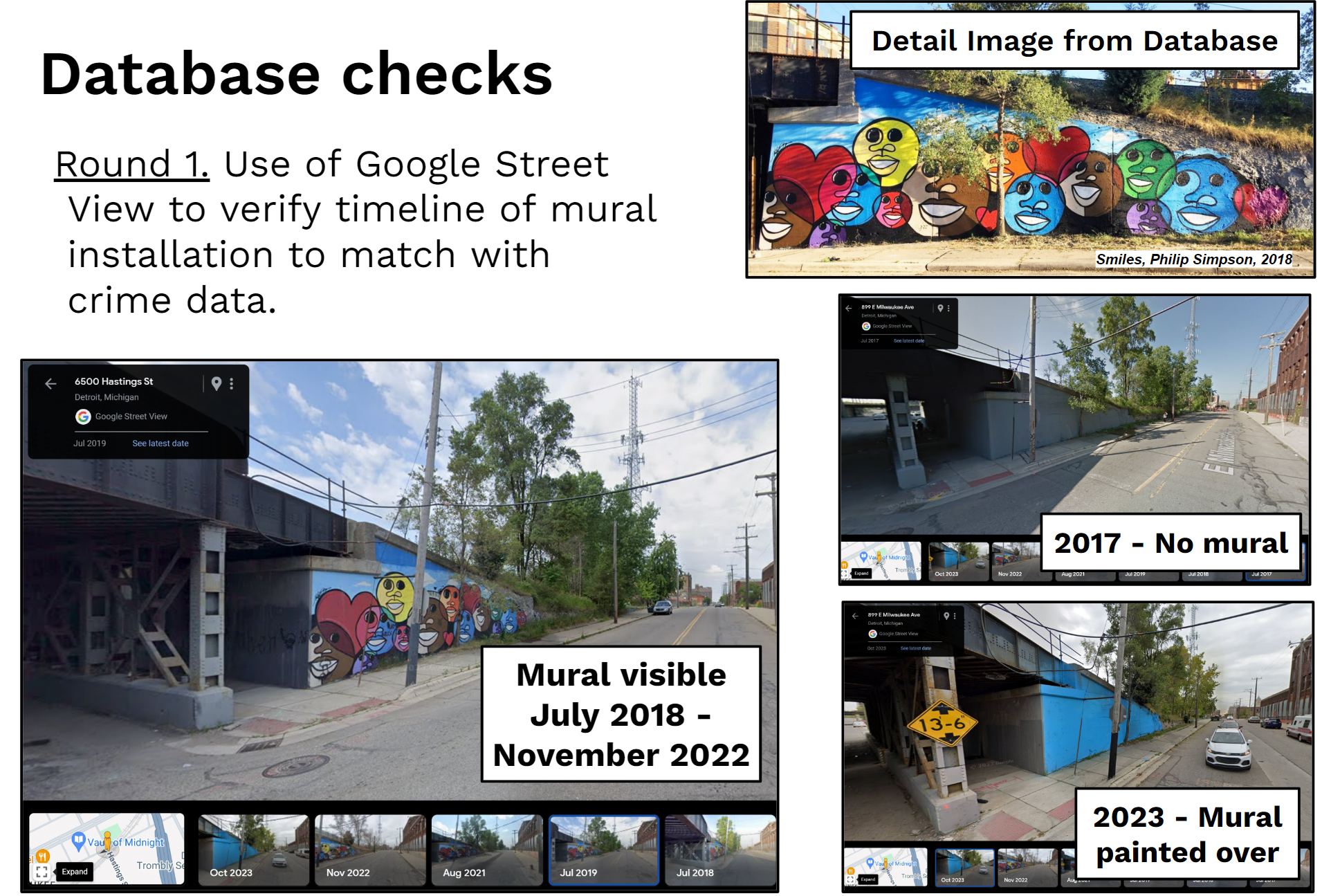
The research team verified the location of each artwork in comparison to its geocoded address by using Google Street View to “walk” through the neighborhoods to find the artwork. The database provides a “detail” reference image as well as a “context” image to help visualize what to look for. Below is an example of the detail image for artwork ID 23, and the Google Street View verification process. The artwork, Smiles by Phillip Simpson (2018) located at 899 E Milwaukee Ave, Detroit, MI, is painted on the outer wall of a railroad underpass.

Mural image credit to Detroit Arts and Culture (2019). https://detroitartsandculture.com/ [Alt-text round 1 use of google street view to verify timeline of mural installation to match with crime data and a collage of photos on google street view from 2017 to 2023 of a mural depicting colorful smiley faces]
In the case of Smiles, the NEA Lab would only seek to analyze any change in crime rates between July 2018 and November 2022, because that is when we have verified the art was on display. Putting a mural on a railroad underpass turned out to be more common than anticipated. We therefore decided these warranted their own category and selected railroad underpasses that did not have murals as control sites for these comparisons.
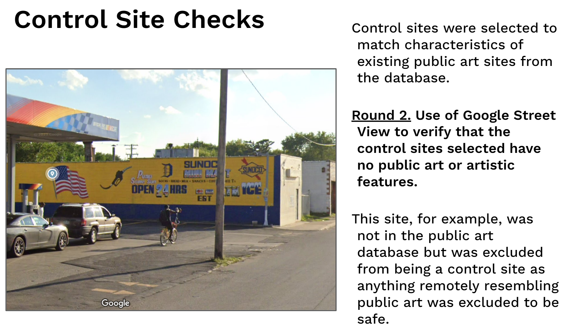
The image below is an example of one of the considerations we weighed when selecting sites with no public art. While the painted logos and advertising on the side of this wall by Sunoco may not be public art in the conventional sense, they do possess artistic elements and thus we decided this site could not serve as an effective control site.

Image credit to Google Street View (2023). [Alt-text Round 2 Use of Google Street View to verify that the control sites selected have no public art or artistic features next to a photo of a gas station parking lot on Google Street View with icons and images painted on the adjacent wall to advertise the Sunoco and Mini Mart]
Glossary of terms
Control site – A site that matches the characteristics of another site except the control site does not have any public art
Treatment site – A site with public art. Control sites are matched based on characteristics of a control site.
Spatial data – Data on the geographic location of a public art site. Geocoding is a form of spatial data that identifies where the public art is located.
Temporal data – Data pertaining to time. For example, the date that the mural was installed or the date that it was painted over.
Crime data – Information on where and when a crime occurred, along with what type of crime was committed